
Take a HIKE! (We mean that in that in a good way…)
What better way to take in the amazing sights and sounds of the great outdoors than with a hiking experience? Any hike will do, from a short half-hour stroll through Marshall Gold Discovery State Historic Park to an all-day hike to the top of Ralston Peak, it really doesn’t matter what you do, as long as you get moving!
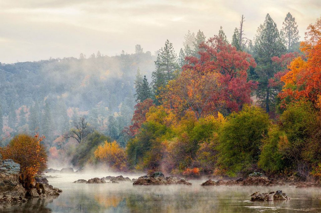
American River Resort is the perfect location as your basecamp for a variety of hiking opportunities. There are miles of trails within walking distance of the Resort, and if you are willing to drive 10 to 20 minutes, there are more than a hundred miles of trail traversing the foothills and running alongside rivers and streams. If you drive for about an hour, you will be rewarded with the opportunity of backcountry travel through the Sierra Nevada Mountains or a hike around Lake Tahoe, world class destinations that are truly magnificent.
Wherever you hike, when finished, your return to the American River Resort will provide the perfect setting to relax and recover. Take the opportunity to cool your feet in the South Fork of the American River as it runs along the Resort… and then plan your next hike. For prime hiking access, the Resort is the best place to stay for a superior experience.
Legendary Hiking in Sierra Nevada Gold Country
Ah, the open trail. There are so many trails around the area and some are only a short drive from the Resort, so we thought we’d give you a short list of our favorites. If you are an avid hiker or a cross-country runner, the area also has trails for you!
Most of the trails in this list are a mixture of miner’s trails, ditches, and modern firebreak roads and trails. Some of these can be combined into longer loop hikes or you can set up car shuttles for longer one-way hikes. There are numerous hiking and running trails, ranging from beginner to advanced in difficulty.
Monroe Ridge Trail and Monument Trail
- Length: 3 miles
- Drive from the Resort: within walking distance
- Difficulty: Beginner to intermediate
- Snapshot: Hike in the hills above historical Coloma. Family friendly
Start on the left side of Hwy 49 from the Resort. One trailhead is in the parking lot on the north end of the park. The other trailhead is near the Marshall statue. The trail is a bit steep at the beginning, but it soon levels out and becomes more enjoyable. You can bring a snack and stop at a picnic table along the trail to enjoy the views. This trail ends at the Marshall Monument, where you can learn about Coloma history while viewing Marshall’s old cabin, a cemetery, a church, and other historical buildings.
Cronan Ranch Trail System
- Length: 12 miles, shorter trails
- Drive from the Resort: 10 minutes
- Difficulty: Beginner to intermediate
- Snapshot: Groomed multi-use, well-marked trails. Family friendly for the most part
Cronan Ranch is in Pilot Hill, just a few miles north of Coloma on Highway 49. The Park has 12 miles of trails for hiking, biking and horseback riding. There are no parking fees. The borders of the Park follow the South Fork American River, Highway 49, Pedro Hill Road and private lands. The Park is open daily from sunrise to sunset year-round. There is a diversity of terrain to choose from, including gently sloped to challenging steep hills, oak woodland and gentle riverfront trails. Cronan Ranch is a must-visit. Plan to spend a full day here. Bring plenty of water and food.
Dave Moore Nature Trail
- Length: 1.1 miles
- Drive from the Resort: 5 minutes
- Difficulty: Beginner
- Snapshot: Family friendly and wheelchair accessible
This nature area is located 2 miles west of the Resort. It starts at the parking lot and goes down to the South Fork of the American River and back, passing through several habitats. This trail contains remnants from nearly 150 years ago, when Chinese laborers channeled creek water by hand with pick and shovel for gold mining.
Dutch Creek and Johntown Falls
- Length: 1.4 miles
- Drive from the Resort: 5 minutes (across the river)
- Difficulty: Intermediate to advanced
- Snapshot: Out-and-back trail across the river from the Resort
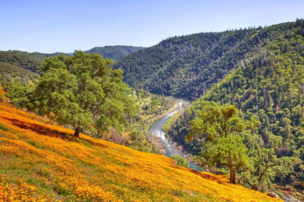
This trail features cascades and historical features related to the Gold Rush era. This is a recommended springtime hike, when poppies line Mt. Murphy and the waterfalls are bursting with snowmelt runoff. Trekking poles may come in handy.
South Fork American River Trail (South Fork ART)
- Length: 11 miles
- Drive from the Resort: 10 minutes
- Difficulty: Intermediate to advanced
- Snapshot: Multi-use trail with magnificent views, a variety of terrain and natural environments
The trailhead is at Cronan Ranch, and parking is free. Start on the main trail and follow signs to the South Fork American River Trail. This trail follows the South Fork of the American River, and is somewhat remote, with no visible homes, roads or signs of civilization for most of the trail. Pack water and food, as much of the trail is exposed to the sun. Follow the Lollipop Tree!
Quarry Trail
- Length: 5.6 miles
- Drive from the Resort: 20 minutes
- Difficulty: Beginner to intermediate
- Snapshot: Gently rolling doubletrack following the Middle Fork of the American River
This trail is wide and smooth (hint: stroller friendly) and is mostly level in grade except for the last bit up to the quarry. It follows the path of the old railway that was used to carry out the limestone and ends in a spectacular amphitheater of sheer limestone walls. Enjoy the majestic views of the American River canyon and peep the remnants of paleontological excavations and mining activities. $10 day-use fee for parking at the trailhead.
WESTERN STATES TRAIL
Each June, ultrarunners tackle the Western States 100-Mile Endurance Run, but everyone can enjoy this wonderful historic trail. The world’s oldest and most prestigious 100-mile trail race starts in Squaw Valley, near the site of the 1960 Winter Olympics and ends 100.2 miles later in Auburn, just 30 minutes from the Resort. If you want to see the ultra-marathoners arrive, you should plan for a June stay at the Resort.
In 2016, Google partnered with the American Trail Running Association and, together, they undertook the enormous task of capturing 360-degree views of the Western States Trail. Make sure you check it out on Street View.
There are a couple of good sections of the WST that you can hike or run, with relative proximity to the Resort.
Training Hill to Pig Farm to Robie Trail Loop
- Length: 2.6 miles
- Drive from the Resort: 20 minutes
- Difficulty: Advanced
- Snapshot: Strenuous, short loop
Technically, this trail is not all part of the Western States, but the last part of the loop is. It starts with the Pointed Rocks Trail on the aptly named Training Hill (750 ft elevation gain over 0.7 mi – yikes!), linking up with the more level Pig Farm and then mercifully joining the Western States Trail at a T-intersection for a more relaxed pace downhill (follow the sign to Auburn). Parking is at the Auburn State Recreation Area with a $10 day-use fee.
Overlook Park to the Confluence
- Length: 5.1 miles
- Drive from the Resort: 35 minutes
- Difficulty: Beginner to intermediate
- Snapshot: Great views!!!
Start at the Overlook Park behind the Gold Country Fairgrounds. The trail begins at the horse watering trough and goes downhill across a shaded creek area, then opening to gorgeous views of the Placer County Water Agency’s pump station and the restored China Bar River Park Area. The WST continues around the canyon edge with several trails entering from the ridge. The trail alternates between wide graded railroad bed and deep ravines. One of the more prominent ravines passes beneath a waterfall named “Black Hole of Calcutta”, which is a great spot to cool off in the summer! Cross the No Hands Bridge and climb on the right to a switchback which is just above and parallel to Highway 49. Come out on Highway 49 at the Confluence of the North and Middle Forks of the American River. You can hike this trail in any direction, and you can also park at the Auburn State Recreation Area with a $10 day-use fee.
Confluence to Cool Quarry
- Length: 3.5 miles
- Drive from the Resort: 20 minutes
- Difficulty: Intermediate to advanced
- Snapshot: Choose your length and difficulty
Start at the Confluence of the North and Middle Forks of the American River. Parking is at the Auburn State Recreation Area with a $10 day-use fee. Head up to the No Hands Bridge and you will see the Western States trailhead on your left. Follow the arrow pointing towards Cool. You can choose to deviate to Training Hill for a harder workout or continue on the WST. Along this hike, you will find breathtaking views of the Foresthill Bridge and the Confluence, old mining equipment and streams where you can stop and cool down. Follow signs to the Western States Trail and you will end up in the Cool Quarry on 49. For a longer hike, you can follow the Wendell T. Robie Trail, or the Olmstead Loop, and you will end up at the Olmstead Trailhead in Cool!
Hiking the Sierra Nevada Mountain and Lake Tahoe
The Sierra Nevada Mountain range has a trail system second to none, and opportunities for hiking and backpacking abound… the drive from the Resort isn’t long, either! The opportunities are too extensive to list here, but below are some trails near Donner Pass, Echo Summit, and Lake Tahoe:
- Horsetail Falls Trail – 4 miles (1-hour drive)
- Ralston Peak – 6.6 miles (1-hour drive)
- Donner Pass Trail – 6.3 miles (1.5-hour drive)
- Echo Lake – 6 miles (1.5-hour drive)
- Cascade Falls Trail – 2 miles (1.5-hour drive)
- Mount Tallac – 9.5 miles (1.5-hour drive)
- Mount Rose – 10 miles (1.5-hour drive)
Tips for Choosing a Hiking Trail
Before you start your search for the perfect hike, it’s helpful to think through a few things, such as:
- How much time you have: Do you have a couple of hours or a full day? Don’t forget to factor in drive times.
- Distance: Think about how many miles and hours you’re comfortable hiking.
- Your fitness level: Assess in an honest manner the shape you’re in. You want to have a great time out there. There are hikes for everyone in the area and you can turn around at any point if you feel like it’s too much.
- Time of year and weather: Some trails don’t have a lot of cover and will not be enjoyable in the summer. Other trails are simply better during the spring, after the flowers have bloomed. Always check the weather forecast before heading out so you can dress and pack appropriately.
- Logistics: Is your hike a loop, or does it start and end at different places? Consider whether you need to set up a shuttle and whether there are parking charges involved.
Trail Etiquette
Whether you’ve been hiking for years or you’re lacing up your boots for your first trek, it’s important to know some basic trail etiquette. Following these rules of the trail can help everyone get along:
- Hikers going uphill have the right of way. You may see uphill hikers let others come downhill while they take a breather, but remember that’s the uphill hiker’s decision. If you’re taking a break, move off the trail to allow other users to pass.
- Mountain bikers should yield to hikers. However, because mountain bikers are usually moving faster than hikers, it can be easier for hikers to step aside and yield the right of way.
- Horses get the right of way. If you’re sharing the trail with equestrians, give them a wide berth and avoid sudden movements. It’s generally recommended to step off the trail to the downhill side while yielding to a horse.
- If you bring your pet with you, make sure to keep it on a leash and under control.
- If hiking with a group, don’t take up the whole width of the trail; be considerate to other users.
- Say a simple “hello”, give a wave or nod when you pass other users of the trail. A little courtesy goes a long way!
Leave No Trace
As with any other outdoor activity, it is essential to follow the rules and regulations laid out by conservation groups and government agencies designed to protect the natural beauty, environment and wildlife of these areas – and you, too! Please remember the seven Leave No Trace (LNT) principles:
- Plan ahead and prepare – Do research on your destination and pack appropriately.
- Travel and camp on durable surfaces – Stay on the trail to minimize erosion.
- Dispose of waste properly – “Pack it in, pack it out”.
- Leave what you find – If you want to take anything, take a picture!
- Minimize campfire impacts (be careful with fire).
- Respect wildlife – Don’t approach animals, and please don’t feed them.
- Be considerate of other visitors – Be courteous and kind to other users of the trail.
What to Wear
In El Dorado County, some of the trails are heavy with poison oak, so you may want to wear a long-sleeved shirt and hiking pants. We recommend layering when hiking during any season. Wear comfortable shoes that provide good traction on trails and near riverside banks. A hat or visor and sunglasses can help keep you stay cool and add extra protection from the sun. Choose clothing made of quick-drying, moisture-wicking fabrics, such as wool or polyester. Avoid cotton, which takes a long time to dry when wet.
What to Bring
Sunscreen and bug repellent are a must, especially if you are hiking in the warmer spring and summer months. Lemon Eucalyptus Oils work great as a DEET-free insect repellent. It is also important to bring water and drinks with electrolytes to keep you hydrated during your walk. Snacks or a picnic lunch are always a good idea. You may want to consider bringing binoculars for bird and wildlife watching. The Laws Field Guide to the Sierra Nevada is a great reference guide to help you identify local flora and fauna, native birds, insects, and trees that you may come across during your journey. If you’re about to leave for your hike and you realize you’re missing something, you may find some of these items at our Camp Store, located inside the Reception building.
For a more comprehensive list, check out REI’s Ten Essentials for hiking.
Trail Safety
- Do not overestimate your abilities. If you are a beginner or haven’t been active a lot, don’t embark on a grueling climb to the top of a hill; you’ll most likely end up hurting yourself. Start short and level. Stick to a trail that suits your taste and level of fitness.
- Bring a friend! While hiking can be a valuable solitary escape, many times the enjoyment and safety both double when hiking with a friend.
- Leave an itinerary behind. List your route and expected time to return. If you are late, people can use your itinerary to find you. And if you’re hiking solo, make sure to text one or two friends, so they can keep tabs on you.
- Stay on the trail. Wandering off the trail can have serious consequences. You could become injured or lost. Some trails have also been built through very delicate habitats and wandering off the trail could disturb and destroy parts of the nature you came to see. As a result, you may occasionally be hiking through some private land. Keep in mind that, in some areas, cell phones and GPS units may not work, so it’s always a good idea to carry a map.
If You Lose Your Way
If you think you’re lost, the first thing you need to do is stop. Look at your guide and see if anything sounds or looks familiar. If not, simply backtrack until your surroundings match those described in your guide. Getting lost hiking is something that just happens (all the time, actually) and it’s not a big deal. Backtracking solves the problem 99% of the time.
At the Finish Line
You did it! You went out there and conquered that trail. Nothing beats that feeling. However, if you did it right, your day is not done. Slow your pace in the last stretch and start cooling down while you’re still on the trail.
Come back to the American River Resort and stretch it out. If you know any basic yoga poses, do them as well; you’ll find that the sounds of nature are more than conducive to relaxation. If meditation is not your thing, you can also use this down time to choose the pictures you’ll be posting on social media. (#AmericanRiver #EpicHike!) Avoid the temptation to collapse in your tent right there and then. Take a relaxing hot shower and keep moving around for a while – it will help your recovery, and you won’t be as sore the next day.
We recommend that you reserve a dinner with us on the day of your hike, so you don’t have to worry about cooking a meal when you’re that exhausted. Take this into consideration when you’re planning your day: dinner is served promptly at 6:00 PM, so make sure you start early and you’re back by then.
After dinner, light up the campfire and roast some marshmallows under the stars. Man, you had the best day!
Resources
All Trails – Great website for finding nearby trails for hiking, biking and horses.
Hiking Project – Also an app! This is a crowd-sourced hiking guide, made for hikers, by hikers. Record and upload your trails.
American Hiking Society – Information about hiking for both beginner and advanced hikers. Good resource for trail advocacy.